First of all you misspelled "plane" and then had the nerve to out it in all caps. This whole flat earth shit is.l the most fuck faced bullshit ever and you dudes are followers. The people who came.up with this flat earth THEORY has never been to space themselves so how could anything they say have any validity?the outer space that nasa shows you is fake yes clown if you will but theres no OUTER space its only a INNER space.nasa says it all the time that they only been to inner space.i know a lot get offended when other people have there own opinion that differs then yall but its cool i know what im saying is right and i speak on whats right period.
flat lol thats how it starts lol circular not flat.the earth isnt flat due to hills valleys etc we live on a flat NON rotating PLAIN..dont get mad at me for saying what nasa been saying for years.look up any nasa doc it will have it on there.non rotating plain.
You are using an out of date browser. It may not display this or other websites correctly.
You should upgrade or use an alternative browser.
You should upgrade or use an alternative browser.
NASA mars Landings are fake and actually filmed in the Gobi desert.
- Thread starter Dr. Truth
- Start date

Rocket science is not something you can figure out with "common sense" and often can seem counterintuitive. For example in the Van Allen Belt most of the radiation (Alpha particles) can be blocked with paper, however 2nd most prevalent type (Beta) needs shielding such as foil paper, in the same manner, certain radio signals are blocked with the same aluminum foil. The reason why they used this foil-type material, is because it works, it's cheap, and also very light, sure it may look flimsy, but for what it's worth it sure gets the job done.I dont believe the united states landed humans on the moon because theres no way in hell the US has the technology to fly 500,000 miles to the moon and back on a single tank of gas on a fucking rocket developed in the 1960's. Plus all 5 moon landings happened under the Nixon Administration. An Administration not known for its honesty. Plus here is a picture of the moon lander

The temperatures of the moon range from -100 to -300 Celsius. Does that aluminum foil looking bullshit look like it was made to withstand those freezing temperatures? We're told the astronauts lived in this thing for 11 days while on the moon. Then magically this piece of shit flew back up and docked with the mother ship hovering 100 miles above the moon floor. A feat never tested on earth but they managed to successfully dock on the first try. I can go on and on but the moon landing was fake
Here is how the fuel consumption worked on the missions.
And for a bonus here is the same guy explaining how the astronauts managed to have enough air to breathe for that many days.
Flat earthers are banking that you don't know this stuff, and other bits of information such as the difference between heat and temperature, to confuse while recruiting people.
Flat earthers are banking that you don't know this stuff, and other bits of information such as the difference between heat and temperature, to confuse while recruiting people.


If I could take an infrared camera, look through the lens and not be able to see anything past the point dictated by the "8" per miles squared" formula for a curved earth, I would finally have to admit that I was wrong and really apologize to you guys for all these years of confusion.....
BUT NIGGA!!!! When an infrared camera can see 1000 MILES away of FLAT SURFACE, sorry yall, just.....sorry yall.....
It's FLAT!!!!!!!
BUT NIGGA!!!! When an infrared camera can see 1000 MILES away of FLAT SURFACE, sorry yall, just.....sorry yall.....
It's FLAT!!!!!!!
Boy, boy, boy....

dude you never been to outer space either lol i mean all you know is what nasa shows you and tell you lol and for the record my boy PLAIN is the word i meant to use and yes my dude its spelled correctly.flat earth isnt a theory its fact.when you in a PLANE what you see ????FLAT the horizon is at eye level my dude and you trying to trash me cause i believe in soething you dont is typicl for negros on here lol thats all yall do is talk smack and bully the ones that cant talk for themselves but you know what? you dont have to read what i say period cause the insults and all that you WAS trying to do didnt work i will still speak the truth on the PLAIN we live on.First of all you misspelled "plane" and then had the nerve to out it in all caps. This whole flat earth shit is.l the most fuck faced bullshit ever and you dudes are followers. The people who came.up with this flat earth THEORY has never been to space themselves so how could anything they say have any validity?
nigga sticking his fingers in his ears talking bout i won again
he a engineer yall already lost
I know, @RoadRage tripping mane! Talk to yo boy!
Meanwhile, can you explain why I can see a flat plane for 1000 miles through an infrared camera???
It's in the video I posted above...
Any idea??


Aight I'm good.
")

Where's the video of this?If I could take an infrared camera, look through the lens and not be able to see anything past the point dictated by the "8" per miles squared" formula for a curved earth, I would finally have to admit that I was wrong and really apologize to you guys for all these years of confusion.....
BUT NIGGA!!!! When an infrared camera can see 1000 MILES away of FLAT SURFACE, sorry yall, just.....sorry yall.....
It's FLAT!!!!!!!
Where's the video of this?
NASA mars Landings are fake and actually filmed in the Gobi desert.
the outer space that nasa shows you is fake yes clown if you will but theres no OUTER space its only a INNER space.nasa says it all the time that they only been to inner space.i know a lot get offended when other people have there own opinion that differs then yall but its cool i know what im...
www.bgol.us
NASA mars Landings are fake and actually filmed in the Gobi desert.
the outer space that nasa shows you is fake yes clown if you will but theres no OUTER space its only a INNER space.nasa says it all the time that they only been to inner space.i know a lot get offended when other people have there own opinion that differs then yall but its cool i know what im...www.bgol.us
 I told you in this very same thread that this is what you do.
Where is the video of the infrared camera that can see 1000 MILES away of FLAT SURFACE?
Don't answer with anything else but this. EXACTLY THIS.
Where is the video of the infrared camera that can see 1000 MILES away of FLAT SURFACE?
Don't answer with anything else but this. EXACTLY THIS.
Dude, what are you talking about?? I posted two videos in this thread of infrared footage? If you click the link I just posted it goes to the video, hold up.....brb
It's Flat.
The higher you ascend, the LOWER the horizon should be on a spherical earth. It should not rise to eye level.

@Walter Panov here they are
So, "they" went into the desert with all this equipment, filmed for days and NOBODY saw them? Not one single soul? Yeah, okay.
It's amazing how the so-called flat earth cult believes in flight yet doesn't believe in other seemingly contradictory elements of physics.
But I need no more proof than this:

It's amazing how the so-called flat earth cult believes in flight yet doesn't believe in other seemingly contradictory elements of physics.
But I need no more proof than this:

The Rocky Mountains are not a flat surface as you claimed. They are 14,440 feet tall.@Walter Panov here they are
And how do you know that first picture is the Rocky Mountains? That just looks like haze. You may be looking at the clouds above the Rocky Mountains.
The Rocky Mountains are not a flat surface as you claimed. They are 14,440 feet tall.
And how do you know that first picture is the Rocky Mountains? That just looks like haze. You may be looking at the clouds above the Rocky Mountains.
Check this out.
When I say the earth is flat, I'm not saying that it doesn't have topology, ie hills and mountains. They verified that it was the Rocky Mountains in the video if you kept watching.
But further, where is the curve? If you look at the Earth curvature calculator, it tells you how far the horizon should reach based on your height. And it also tells you how much bulge or curve (target hidden height) there should be blocking your view. You should NOT be able to see that far on a ball earth. It's ONLY possible on a flat plane. The infrared let's you see way further than a regular camera, which is where the dude said it's not only flat, it's EXTREMELY flat.
Earth Curve Calculator
dizzib.github.io
AND beyond the Rocky Mountains, you can see the horizon, which STILL rises to eye level.
Ain't no way around this, it's flat.
Why didn't they fly to the edge? I've been to the edge many of times.@Walter Panov here they are
Flat Earthers claim refraction explains why the Sun always looks the same size no matter how far away it is but say refraction doesn't exist when it explains why you can see things beyond the curvature of the Earth lmao.Check this out.
When I say the earth is flat, I'm not saying that it doesn't have topology, ie hills and mountains. They verified that it was the Rocky Mountains in the video if you kept watching.
But further, where is the curve? If you look at the Earth curvature calculator, it tells you how far the horizon should reach based on your height. And it also tells you how much bulge or curve (target hidden height) there should be blocking your view. You should NOT be able to see that far on a ball earth. It's ONLY possible on a flat plane. The infrared let's you see way further than a regular camera, which is where the dude said it's not only flat, it's EXTREMELY flat.
Earth Curve Calculator
dizzib.github.io
AND beyond the Rocky Mountains, you can see the horizon, which STILL rises to eye level.
Ain't no way around this, it's flat.
Got to cherry pick facts to flerf.Flat Earthers claim refraction explains why the Sun always looks the same size no matter how far away it is but say refraction doesn't exist when it explains why you can see things beyond the curvature of the Earth lmao.
Why are you people so fixated on NASA? You realize there are hundreds of agencies/universities that can make these same measurements independently. The spherical nature of Earth has been known for thousands of years with pretty good estimates of its size.NASA told you that huh?
I have a physics degree, so I've derived Kepler's laws of motion myself. I also understand, with math, why objects above a certain size form spheres.
And I've seen Jupiter and Saturn through my own telescope many times and you can see the poles look slightly "squished".
Seeing clouds from what they claim is 1,000 miles away and calling them the Rocky Mountains does not verify anything. Flying towards the Rocky Mountains and pointing at them does not negate that fact. They could have pointed to some random car and said "See! I told you you could see a car from a 1,000 miles away". Except we never saw it. We only saw clouds.Check this out.
When I say the earth is flat, I'm not saying that it doesn't have topology, ie hills and mountains. They verified that it was the Rocky Mountains in the video if you kept watching.
But further, where is the curve? If you look at the Earth curvature calculator, it tells you how far the horizon should reach based on your height. And it also tells you how much bulge or curve (target hidden height) there should be blocking your view. You should NOT be able to see that far on a ball earth. It's ONLY possible on a flat plane. The infrared let's you see way further than a regular camera, which is where the dude said it's not only flat, it's EXTREMELY flat.
Earth Curve Calculator
dizzib.github.io
AND beyond the Rocky Mountains, you can see the horizon, which STILL rises to eye level.
Ain't no way around this, it's flat.
The "1,000 mile picture" is a picture of clouds that are probably 100 miles away. And what eye level are you looking at from an airplane?
Flat Earthers claim refraction explains why the Sun always looks the same size no matter how far away it is but say refraction doesn't exist when it explains why you can see things beyond the curvature of the Earth lmao.
Goddamn man?!?
I never said refraction doesn't exist, but in infrared footage REFRACTION is not flattening out the ball earth so you can see things 1000 miles away where you see pure flatness AND the horizon is STILL AT EYE LEVEL!!. Talk about a goddamn STRETCH!!
Give it up bruh, you can't refract your way out of this, this muthafucka is FLAT! Case CLOSED!!!
can you point me to the infrared vid you are talking aboutGoddamn man?!?
I never said refraction doesn't exist, but in infrared footage REFRACTION is not flattening out the ball earth so you can see things 1000 miles away where you see pure flatness AND the horizon is STILL AT EYE LEVEL!!. Talk about a goddamn STRETCH!!
Give it up bruh, you can't refract your way out of this, this muthafucka is FLAT! Case CLOSED!!!
i want to see it
The 8 inches/mi^2 is a small angle approximation that only applies over the limited distances where a parabola approximate a sphere. So maybe tens of miles. I've also derived that formula and it comes from the assumption that sin(angle) ~= angle for angles on the order of a few degrees.
Also in this video, where he shows the location of the Rockies versus the flight path of the plane, you see several closer mountain ranges near the plane.
Seeing clouds from what they claim is 1,000 miles away and calling them the Rocky Mountains does not verify anything. Flying towards the Rocky Mountains and pointing at them does not negate that fact. They could have pointed to some random car and said "See! I told you you could see a car from a 1,000 miles away". Except we never saw it. We only saw clouds.
The "1,000 mile picture" is a picture of clouds that are probably 100 miles away. And what eye level are you looking at from an airplane?
dude first off,
Those are not clouds where it says Appalachian Mtns, which are 500 MILES away. Further, the horizon extends what appears to be another 500 miles. A thousand+ miles.
Then this picture which I assume you are talking about,
Those are mountains, not clouds. You can say they look like clouds, but the video in full context verifies that they are in fact the Rocky Mountains.
I know you are skeptical/devil's advocate right now, but there is far more than one example. The BIG PICTURE is that you can still see the ground from 1000+ of miles away. There is NO WAY POSSIBLE you can do that on a BALL first of all, because the curvature would block it and secondly, the horizon would appear further and further down the more you vertically ascend. AND REFRACTION WOULD NOT FLATTEN THE BALL! This is not even a close argument, the infrared footage OVERWHELMINGLY PROVES THE EARTH IS FLAT.
Last edited:
Why are you people so fixated on NASA? You realize there are hundreds of agencies/universities that can make these same measurements independently. The spherical nature of Earth has been known for thousands of years with pretty good estimates of its size.
I have a physics degree, so I've derived Kepler's laws of motion myself. I also understand, with math, why objects above a certain size form spheres.
And I've seen Jupiter and Saturn through my own telescope many times and you can see the poles look slightly "squished".
Dude, those universities and other agencies get their information from the top down, meaning NASA. You have to get the information from a source first before you start teaching it.
I have posted peer-reviewed examples of anomalies that had scientists BAFFLED, because reality didn't fit their theoretical model. And scientists continue you be BAFFLED, ALL THE FUCKING TIME because there are constant announcements of it when things go beyond their "scientific" understanding of reality. Of course, yall ignored that.
The spherical nature has NOT been known for thousands of years. Watch this video, and take note that this is NOT a flat earth video.
Goddamn man?!?
I never said refraction doesn't exist, but in infrared footage REFRACTION is not flattening out the ball earth so you can see things 1000 miles away where you see pure flatness AND the horizon is STILL AT EYE LEVEL!!. Talk about a goddamn STRETCH!!
Give it up bruh, you can't refract your way out of this, this muthafucka is FLAT! Case CLOSED!!!
This completely destroys your view, but you'll just respond with laughing emojis.

Pic Gaspard (3880m)/Grand Ferrand (2758m) from Pic de Finestrelles (2826m) in the Pyrénées
I have some new toys to share in this installment of 'Yes, the Earth really is Curved even though you can see one distant mountain peak from...
 flatearthinsanity.blogspot.com
Tuesday, November 28, 2017
Pic Gaspard (3880m)/Grand Ferrand (2758m) from Pic de Finestrelles (2826m) in the Pyrénées
I have some new toys to share in this installment of 'Yes, the Earth really is Curved even though you can see one distant mountain peak from another', so this should be fun!
This time we're going to look at a view of two distant mountains from Pic de Finestrelles (2826m) in the Pyrénées, taken by Marc Bret of Beyond Horizons (see also the Flickr album).
Pic Gaspard (3880m) in the Massif des Écrins range at a distance of 443 km.
Grand Ferrand (2758m) at a distance of 392.48 km.
Our view is right around 42.414466°N, 2.132839°E at about 2826 meters elevation, looking right along the coast.
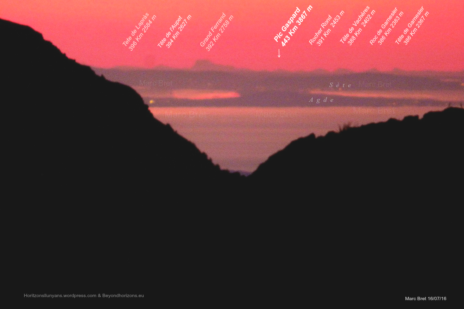 |
| Pic Gaspard/Grand Ferrand from Pic de Finestrelles in the Pyrénées, image by Marc Bret |
The EXIF metadata shows this image was taken by a Panasonic DMC-FZ72 with a focal length of 215mm -- given the 5.62 crop factor of the 1/2.3" sensor in this camera, this gives you a 35mm equivalent focal length of 1200mm giving a full frame view of 1.644° wide and 1.215° high.
Since 1521 x 1014 isn't the exact same aspect ratio as the size of image this camera shoots it's likely that some small amount of cropping has taken place.
To double check this we can draw lines from our viewpoint to each peak and we find that, at the distance of Ferrand (392.48 km), our lines are about 1.7 km apart. This gives us an angle of approximately 0.24817° -- if we then apply that over the full 1521 pixels of the image we get an estimate of 1.63° wide -- very close to the 1.644° we expect so let's just use 1.644° / 1.215° as our field of view.
Now we're in a very good position to size the mountain and compare it to our photo.
First, we need the Law of Perspective, which says that the angular size (α) of an object whose height perpendicular to our line of sight (g) at distance (r) is:
α = 2*arctan(g/2/r)
Excellent - we just need to know the height and the distance.
Pic Gaspard (3880m) @ 443 km = 2*arctan(3.880/2/443) = 0.5018° = 461 pixelsTechnically, we should find the straight-line distance but at 440 km it doesn't change the answer much. If you want to find the straight-line distance from a curved distance (o) along the surface of the Earth you could use this formula (where R is Earth's radius of curvature, for 42°N latitude R ~ 6369km):
g = R*2*sin((o/R)/2) = 6369*2*sin((443/6369)/2) = 442.9 km
So let's just keep it simple since this would be about 1/1000th of a degree.
Grand Ferrand (2758m) @ 392.48 km = 2*arctan(2.758/2/392.48) = 0.4026° = 375 pixels
Just for scale, one-half a degree is the apparent size of the Moon, so we're talking about a pinkie-at-arms-length size -- but that that is the size those mountains should appear at the distances they are from this observer.
So we can mark those out on the image now as the full height of the mountain at that distance.
As expected, the "sea-level" bottom for the more distant mountain (Gaspard) is lower than the closer mountain (Ferrand) and since it's a larger mountain the total apparent size is larger even though it's slightly further away.

So please do not try to tell me we're seeing the "whole mountain" here.
Now, Walter Bislin has an amazing calculator that will let you place objects in the world and includes a very advanced refraction module (which I left at defaults except to set the 'surveying standard' 7/6th refraction, about 14%. This is very modest amount of refraction and since the photographer tells you that this is very rare to be able to see this, the actual refraction is likely greater than shown here.
Here is Ferrand and Gaspard on a Globe model vs a Flat Earth model. Notice how the Globe model correctly shows just the distant peaks with Ferrand peak above Gaspard even though Ferrand is shorter. When you put these two mountains on a flat plane then Gaspard clearly stands taller.
There is no contest here, the Globe best fits the observations and really ONLY fits the observations. If we could see the entire mountain, even at this great distance with perspective, they would stand vastly larger than seen here.
 |
| Walter Bislin Horizon Rendering Tool (link) |
Another fun tool that comes from the Beyond Horizons page is a 'panorama' rendering tool that will label the mountain peaks. I've used PeakFinder in the past but this one seems to be more full featured. Here is our approximate view:
 |
| View of Grand Ferrand from Finestrelles via udeuschle panorama generator |
So this view comports with the Globe model extremely well and utterly destroys the Flat Earth model. The problem is that Flat Earthers do not how to do basic estimations like how big something would be in an image (if you could see the whole thing).
This completely destroys your view, but you'll just respond with laight emojis.
Pic Gaspard (3880m)/Grand Ferrand (2758m) from Pic de Finestrelles (2826m) in the Pyrénées
I have some new toys to share in this installment of 'Yes, the Earth really is Curved even though you can see one distant mountain peak from...
Tuesday, November 28, 2017
Pic Gaspard (3880m)/Grand Ferrand (2758m) from Pic de Finestrelles (2826m) in the Pyrénées
I have some new toys to share in this installment of 'Yes, the Earth really is Curved even though you can see one distant mountain peak from another', so this should be fun!
This time we're going to look at a view of two distant mountains from Pic de Finestrelles (2826m) in the Pyrénées, taken by Marc Bret of Beyond Horizons (see also the Flickr album).
Pic Gaspard (3880m) in the Massif des Écrins range at a distance of 443 km.
Grand Ferrand (2758m) at a distance of 392.48 km.
Our view is right around 42.414466°N, 2.132839°E at about 2826 meters elevation, looking right along the coast.
Pic Gaspard/Grand Ferrand from Pic de Finestrelles in the Pyrénées, image by Marc Bret
The EXIF metadata shows this image was taken by a Panasonic DMC-FZ72 with a focal length of 215mm -- given the 5.62 crop factor of the 1/2.3" sensor in this camera, this gives you a 35mm equivalent focal length of 1200mm giving a full frame view of 1.644° wide and 1.215° high.
Since 1521 x 1014 isn't the exact same aspect ratio as the size of image this camera shoots it's likely that some small amount of cropping has taken place.
To double check this we can draw lines from our viewpoint to each peak and we find that, at the distance of Ferrand (392.48 km), our lines are about 1.7 km apart. This gives us an angle of approximately 0.24817° -- if we then apply that over the full 1521 pixels of the image we get an estimate of 1.63° wide -- very close to the 1.644° we expect so let's just use 1.644° / 1.215° as our field of view.
Now we're in a very good position to size the mountain and compare it to our photo.
First, we need the Law of Perspective, which says that the angular size (α) of an object whose height perpendicular to our line of sight (g) at distance (r) is:
α = 2*arctan(g/2/r)
Excellent - we just need to know the height and the distance.
Pic Gaspard (3880m) @ 443 km = 2*arctan(3.880/2/443) = 0.5018° = 461 pixels
Grand Ferrand (2758m) @ 392.48 km = 2*arctan(2.758/2/392.48) = 0.4026° = 375 pixels
Just for scale, one-half a degree is the apparent size of the Moon, so we're talking about a pinkie-at-arms-length size -- but that that is the size those mountains should appear at the distances they are from this observer.
So we can mark those out on the image now as the full height of the mountain at that distance.
As expected, the "sea-level" bottom for the more distant mountain (Gaspard) is lower than the closer mountain (Ferrand) and since it's a larger mountain the total apparent size is larger even though it's slightly further away.
So please do not try to tell me we're seeing the "whole mountain" here.
Now, Walter Bislin has an amazing calculator that will let you place objects in the world and includes a very advanced refraction module (which I left at defaults except to set the 'surveying standard' 7/6th refraction, about 14%. This is very modest amount of refraction and since the photographer tells you that this is very rare to be able to see this, the actual refraction is likely greater than shown here.
Here is Ferrand and Gaspard on a Globe model vs a Flat Earth model. Notice how the Globe model correctly shows just the distant peaks with Ferrand peak above Gaspard even though Ferrand is shorter. When you put these two mountains on a flat plane then Gaspard clearly stands taller.
There is no contest here, the Globe best fits the observations and really ONLY fits the observations. If we could see the entire mountain, even at this great distance with perspective, they would stand vastly larger than seen here.
Walter Bislin Horizon Rendering Tool (link)
Another fun tool that comes from the Beyond Horizons page is a 'panorama' rendering tool that will label the mountain peaks. I've used PeakFinder in the past but this one seems to be more full featured. Here is our approximate view:
View of Grand Ferrand from Finestrelles via udeuschle panorama generator
So this view comports with the Globe model extremely well and utterly destroys the Flat Earth model. The problem is that Flat Earthers do not how to do basic estimations like how big something would be in an image (if you could see the whole thing).
So imagine what that pic would look like taken with an infrared camera. You would see far beyond those mountains to the REAL HORIZON, which is more toward the top of the pic and you can faintly see it. On the image below, that horizon on the Flat Earth example is FALSE.
This such an elementary argument wrapped in pretentiousness. Gaspard is the taller mountain, but it's further away so it appears smaller......DUHHHH!!!!!!! Are you fucking SERIOUS!?? A 35mm camera EXPANDS an image compared to human eyesight. Humans see at 50-60mm, so anything above 60mm makes "objects appear closer than they really are" (COMPRESSION) and anything below 50mm makes "objects appear further than they really are" (EXPANSION). It also makes objects appear smaller!

All this is irrelevant because nobody's arguing the size of mountains, thinking that the bigger mountain looks smaller because it's falling behind a curve when an infrared camera shows you all the land BEHIND THOSE MOUNTAINS!!
LMAO@Cashie B not believing Copernicus but 100% believing random people on the internet.
Keep laughing. So believe Copernicus before I believe my OWN FUCKING EYES!??
See, that's the indoctrination right there!! BLATANT!
Laugh all you want, call me names like ya boy Trump, but you CANNOT REFUTE THAT INFRARED CAMERA BRUH!! YOU CAN'T!!
Similar threads
- Replies
- 2
- Views
- 114
- Replies
- 7
- Views
- 288
- Replies
- 51
- Views
- 1K